
Venues
A way for me to find places when I travel or go somewhere: what is around me, a map that follows me on foot or at the wheel, a trip planned around one area, what the house has learned about each place, how long the drive takes and where to leave the car. It is part of the same internal website.
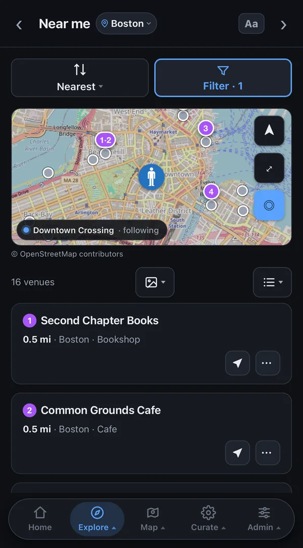
- Near me, search and the mapWhat is near me right now, search, and a map with my current position snapped to the road I am on.
The mapEvery place on one full-screen map I can turn, tilt and filter.
Pins are drawn on the phone’s graphics chip, coloured by their score, with a green or red ring for open or closed right now, and a closed one is dimmed so the open ones stand out. Names appear from neighbourhood zoom in and never cover a pin or a button. A tap on a pin opens a small card with a photo, the distance, Directions and the full page, without loading a page; pins on the same spot open as a list. The lists’ own filters apply here too, the map can be streets, satellite or both, and it can bring in a listing service’s places for the area on screen.
DriveOne tap turns the map into a driving view.
It sets heading-up, tilts the map to 3D, follows me and puts the car low on the screen, so 40 percent of the map’s height is kept for the road ahead, at a zoom of about the next two turns in town. A second tap goes flat and north-up without the map jumping. Directions on a place hand the route to a maps app; the house itself gives no turn-by-turn directions.
A car, a walker or standingMy position on the map is drawn as a car, a walker or a standing figure.
The icon is picked from my speed over a seven-second window, never one GPS reading: it becomes a car after 4 seconds above 10 mph, a red light does not turn it back, and only 25 seconds of moving at walking pace does; below 1.6 mph for 4 seconds it stands. The car points the way I am moving, while the walker and the standing figure point the way the phone faces, from its compass. On a recorded drive the earlier marker showed a car 19 percent of the time and this one 62 percent, with a quarter of the icon flips. I can also fix it to car or walker by hand.
Where I am, nowKeeps my dot on the road and where I really am, not seconds behind.
On a recorded drive the phone’s raw readings ran 25 to 60 metres off. A smoother that tracks speed as well as position takes out the jitter, a matcher puts each reading on the likeliest road in the house’s own road map, and while driving the dot is projected ahead by the reading’s age plus 350 milliseconds, at most 2.2 seconds through a dropout. If no new reading arrives for 15 seconds the app restarts location and says so, and a position older than 30 seconds shows its age.
Recording a routeRecords where I went and draws it back as a path.
It keeps going across the whole app, not only on the map, and pauses only when the phone is locked or the app is in the background. It keeps a point every 8 feet of movement, or every 5 seconds while still, never more than two a second. A past recording can be laid over the map, renamed, deleted, or replayed through the live marker to tune it.
Radar and area factsArrows to the nearest places, and facts about the area I am looking at.
The radar points at the 5 closest to the centre of the map, so it follows the map as it pans, turns and tilts, either as a plain list or as a video-game heads-up display. Area intel shows population, household income, home value and age for the census tract under the centre, from a census table kept on the machine, so nothing about where I am looking is asked online.
- BasesThe places I am staying are bases that every distance is measured from.
Trip planningFinds groups of places close enough to build a trip around one area.
Close enough means every pair is within a chosen distance; a faster search took the planner from 19.4 seconds to 0.86 with the same answer.
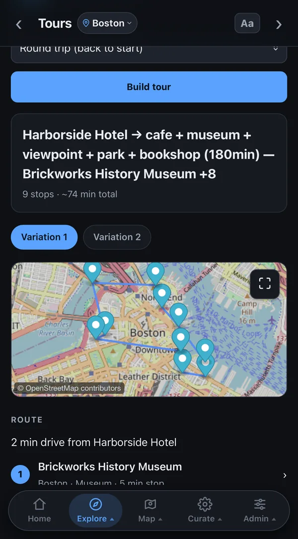
ToursBuilds a route of stops that fits the time I have.
It counts the drive and the time spent at each stop, packs in as many as fit a time budget from a starting point, as a round trip or one way with detours along a corridor, and offers several versions; or it fills a sequence of slots with the shortest total time.
Leave byTells me when to leave to arrive on time.
The drive comes from the house’s own router to the parking lot it picked, plus the walk from that lot. Until I set an arrival, it aims for the earliest closing time among the stops minus the time the plan needs there. A weekday drive overlapping 4:30 to 6:30 in the evening is scaled by 1.30, the factor measured on 12 rush-hour trips.
Research agentsAgents that look for new places.
Each place they propose is checked against a real listing to prove it exists, matched against what the site already has, and added only after I review it.
Research on a place I haveAn agent researches a place already on the site and adds what it finds.
It runs on Claude Opus with web search and files its findings under ten headings, among them what is good, what to avoid, reviews, tips, ownership, history and news. Every finding carries a link to each site it came from and a confidence of high, medium or low; only web links are accepted, anything already known is dropped, at most 60 are kept from a run, and the write can touch nothing but the research notes, never the place’s name, details or score. I can watch each search it makes while it runs and stop it, and it runs at most once a week for a place unless I force it.
Keeping places currentCatches a place that closed, changed its name or changed its hours.
A free check with the listing service sweeps a whole list for closures and renames; a fuller one refreshes the hours, phone and website and scores the place again. Every change lands in a Changes feed, newest first, marking what is new since my last look, and a saved filter can be watched: a member then gets at most one message every five minutes naming each place and what changed, with links.
Driving times without a maps serviceTells me how long a drive takes without asking a maps service.
The house routes on its own road graph built from OpenStreetMap, 390,714 junctions for the whole state, with an A* search that answers a 30-mile route in at most 0.13 seconds of computing and calls nothing outside. Its speeds were fitted to a one-off sample of trips from a commercial router and scored only on trips the fit never saw: 33 of 45 land within 3 minutes of the commercial router’s time.
- 390,714 road junctions in its own map of the state
- 0.13 s to route a 30-mile drive, at most
- 33 / 45 test trips within 3 minutes of a commercial router
A safe place to leave the carFinds a safe place to leave the car near where I am going.
The finder starts from 45,152 parking lots from OpenStreetMap, each tied to the business within 60 metres whose lot it is, and where the map is thin a model reads satellite imagery: on 30 known spots the map had missed, it found 27. Every candidate gets a real walking route, then an agent looks at each from above, checks its opening hours for the time of the visit and proposes 2–4 spots; nothing is saved until I accept it.
- 45,152 parking lots in its map
- 27 / 30 lots the map was missing, found in satellite images
- 2–4 spots it proposes for each visit